


Test1
© OpenStreetMap contributors


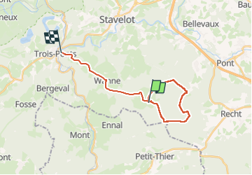
4h21
Difficulty : Very difficult


")
Length
19.3 km
Max alt
614 m
Uphill gradient
266 m
Km-Effort
23 km
Min alt
341 m
Downhill gradient
464 m
Boucle
No
Creation date :
2025-02-23 09:22:59.717
Updated on :
2025-02-23 13:44:38.513
4h21
Difficulty : Very difficult
FREE GPS app for hiking
 SityTrail
IGN / Geographical institutes
SityTrail Plus
The world is yours!
About
Trail Walking of 19.3 km to be discovered at Wallonia, Liège, Trois-Ponts. This trail is proposed by thomas bastin (Arkios).
Positioning
Country:
Belgium
Region :
Wallonia
Department/Province :
Liège
Municipality :
Trois-Ponts
Location:
Unknown
Start:(Dec)
Start:(UTM)
710741 ; 5580850 (31U) N.
Comments