


merindol 41km

mthomas30
User
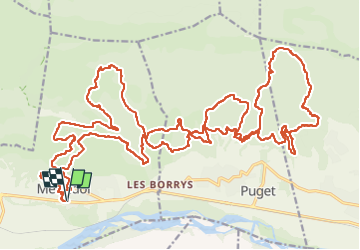

Length
42 km

Max alt
587 m

Uphill gradient
1598 m
Km-Effort
63 km

Min alt
143 m

Downhill gradient
1596 m
Boucle
Yes
Creation date :
2025-02-23 07:16:32.284
Updated on :
2025-02-23 14:15:48.876
5h23
Difficulty : Difficult

FREE GPS app for hiking
 SityTrail
IGN / Geographical institutes
SityTrail Plus
The world is yours!
About
Trail Mountain bike of 42 km to be discovered at Provence-Alpes-Côte d'Azur, Vaucluse, Mérindol. This trail is proposed by mthomas30.
Positioning
Country:
France
Region :
Provence-Alpes-Côte d'Azur
Department/Province :
Vaucluse
Municipality :
Mérindol
Location:
Unknown
Start:(Dec)
Start:(UTM)
677470 ; 4846745 (31T) N.
Comments