


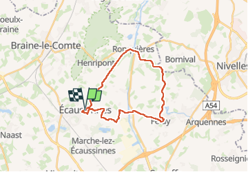
Boucle GR Ecaussines - Feluy - Ronquières

CapTom
User

Length
22 km

Max alt
122 m

Uphill gradient
213 m
Km-Effort
25 km

Min alt
53 m

Downhill gradient
219 m
Boucle
Yes
Creation date :
2025-02-23 09:36:46.0
Updated on :
2025-02-23 14:38:11.148
4h30
Difficulty : Very difficult

FREE GPS app for hiking
 SityTrail
IGN / Geographical institutes
SityTrail Plus
The world is yours!
About
Trail Walking of 22 km to be discovered at Wallonia, Hainaut, Écaussinnes. This trail is proposed by CapTom.
Positioning
Country:
Belgium
Region :
Wallonia
Department/Province :
Hainaut
Municipality :
Écaussinnes
Location:
Unknown
Start:(Dec)
Start:(UTM)
583243 ; 5602604 (31U) N.
Comments