


Champsaur: Prapic - Saut du Laire

ARPF
User
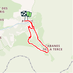

Length
12.5 km

Max alt
2069 m

Uphill gradient
570 m
Km-Effort
20 km

Min alt
1537 m

Downhill gradient
540 m
Boucle
No
Creation date :
2015-06-21 00:00:00.0
Updated on :
2015-06-21 00:00:00.0
4h07
Difficulty : Difficult

FREE GPS app for hiking
 SityTrail
IGN / Geographical institutes
SityTrail Plus
The world is yours!
About
Trail Walking of 12.5 km to be discovered at Provence-Alpes-Côte d'Azur, Hautes-Alpes, Orcières. This trail is proposed by ARPF.
Description
IE: 86 P2 T2 2015-06-18
Beau parcours
Positioning
Country:
France
Region :
Provence-Alpes-Côte d'Azur
Department/Province :
Hautes-Alpes
Municipality :
Orcières
Location:
Unknown
Start:(Dec)
Start:(UTM)
291310 ; 4952252 (32T) N.
Comments