


activity_18361674086

ARPF
User
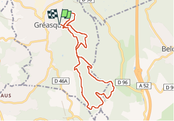

Length
10.2 km

Max alt
398 m

Uphill gradient
184 m
Km-Effort
12.6 km

Min alt
284 m

Downhill gradient
183 m
Boucle
Yes
Creation date :
2025-02-24 15:06:49.417
Updated on :
2025-03-04 16:11:29.261
0m
Difficulty : Very easy

FREE GPS app for hiking
 SityTrail
IGN / Geographical institutes
SityTrail Plus
The world is yours!
About
Trail Nordic walking of 10.2 km to be discovered at Provence-Alpes-Côte d'Azur, Bouches-du-Rhône, Gréasque. This trail is proposed by ARPF.
Positioning
Country:
France
Region :
Provence-Alpes-Côte d'Azur
Department/Province :
Bouches-du-Rhône
Municipality :
Gréasque
Location:
Unknown
Start:(Dec)
Start:(UTM)
706151 ; 4811956 (31T) N.
Comments