


Puy de Lassolas/ Puy de la Vache/ Puy de Vichatel

geoffrayLayeux
User

Length
12.3 km

Max alt
1174 m

Uphill gradient
454 m
Km-Effort
18.4 km

Min alt
952 m

Downhill gradient
454 m
Boucle
Yes
Creation date :
2025-02-24 16:07:39.436
Updated on :
2025-02-24 16:09:15.719
4h10
Difficulty : Difficult

FREE GPS app for hiking
 SityTrail
IGN / Geographical institutes
SityTrail Plus
The world is yours!
About
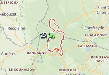
Trail Walking of 12.3 km to be discovered at Auvergne-Rhône-Alpes, Puy-de-Dôme, Aydat. This trail is proposed by geoffrayLayeux.
Positioning
Country:
France
Region :
Auvergne-Rhône-Alpes
Department/Province :
Puy-de-Dôme
Municipality :
Aydat
Location:
Unknown
Start:(Dec)
Start:(UTM)
496196 ; 5059955 (31T) N.
Comments