


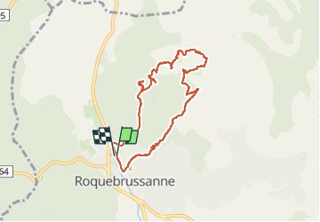
SityTrail - Source des Orris rochers menhirs (83)

Mare Nostrum
User


FREE GPS app for hiking
 SityTrail
IGN / Geographical institutes
SityTrail Plus
The world is yours!
About
Trail of 8.2 km to be discovered at Provence-Alpes-Côte d'Azur, Var, La Roquebrussanne. This trail is proposed by Mare Nostrum.
Description
Boucle par la chapelle Notre Dame,la source des Orris,montée par la cheminée hard,mais avec de bonnes prises.Pas Gravet,les nombreux rochers menhirs, le doigt vers le ciel,grotte à moutons, et la chapelle St André de la louve,très bien caché.( A voir 10 min AR.)
Positioning
Comments