


Routo Puimoisson Riez

taguette
User
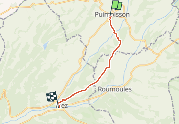

Length
8.1 km

Max alt
695 m

Uphill gradient
93 m
Km-Effort
9.9 km

Min alt
521 m

Downhill gradient
263 m
Boucle
No
Creation date :
2025-02-25 13:34:29.118
Updated on :
2025-02-25 15:37:17.028
2h02
Difficulty : Medium

FREE GPS app for hiking
 SityTrail
IGN / Geographical institutes
SityTrail Plus
The world is yours!
About
Trail Walking of 8.1 km to be discovered at Provence-Alpes-Côte d'Azur, Alpes-de-Haute-Provence, Puimoisson. This trail is proposed by taguette.
Positioning
Country:
France
Region :
Provence-Alpes-Côte d'Azur
Department/Province :
Alpes-de-Haute-Provence
Municipality :
Puimoisson
Location:
Unknown
Start:(Dec)
Start:(UTM)
269103 ; 4860604 (32T) N.
Comments