


OVB2025-GR30-01

frlrt
User
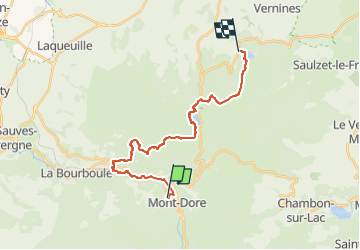

Length
21 km

Max alt
1486 m

Uphill gradient
960 m
Km-Effort
33 km

Min alt
888 m

Downhill gradient
793 m
Boucle
No
Creation date :
2025-02-25 17:08:28.305
Updated on :
2025-03-15 16:16:12.224
7h36
Difficulty : Very difficult

FREE GPS app for hiking
 SityTrail
IGN / Geographical institutes
SityTrail Plus
The world is yours!
About
Trail Walking of 21 km to be discovered at Auvergne-Rhône-Alpes, Puy-de-Dôme, Mont-Dore. This trail is proposed by frlrt.
Description
Mont Dore ---Servière
Positioning
Country:
France
Region :
Auvergne-Rhône-Alpes
Department/Province :
Puy-de-Dôme
Municipality :
Mont-Dore
Location:
Unknown
Start:(Dec)
Start:(UTM)
484611 ; 5047123 (31T) N.
Comments