


chars marines

olivieraron
User
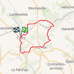

Length
21 km

Max alt
209 m

Uphill gradient
369 m
Km-Effort
26 km

Min alt
57 m

Downhill gradient
368 m
Boucle
Yes
Creation date :
2019-01-14 09:45:33.801
Updated on :
2025-03-24 13:47:29.67
5h00
Difficulty : Unknown

FREE GPS app for hiking
 SityTrail
IGN / Geographical institutes
SityTrail Plus
The world is yours!
About
Trail Other activity of 21 km to be discovered at Ile-de-France, Val-d'Oise, Chars. This trail is proposed by olivieraron.
Positioning
Country:
France
Region :
Ile-de-France
Department/Province :
Val-d'Oise
Municipality :
Chars
Location:
Unknown
Start:(Dec)
Start:(UTM)
422473 ; 5446081 (31U) N.
Comments