


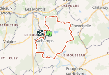
Ouchamps

Pascal Bernaud
User

Length
14.4 km

Max alt
110 m

Uphill gradient
126 m
Km-Effort
16.1 km

Min alt
73 m

Downhill gradient
126 m
Boucle
Yes
Creation date :
2025-02-26 08:05:21.0
Updated on :
2025-02-26 11:09:44.879
3h03
Difficulty : Difficult

FREE GPS app for hiking
 SityTrail
IGN / Geographical institutes
SityTrail Plus
The world is yours!
About
Trail Walking of 14.4 km to be discovered at Centre-Loire Valley, Loir-et-Cher, Le Controis-en-Sologne. This trail is proposed by Pascal Bernaud.
Positioning
Country:
France
Region :
Centre-Loire Valley
Department/Province :
Loir-et-Cher
Municipality :
Le Controis-en-Sologne
Location:
Unknown
Start:(Dec)
Start:(UTM)
372570 ; 5259009 (31T) N.
Comments