


20250226 Leves

Jeanclaudebic
User
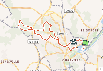

Length
8.9 km

Max alt
162 m

Uphill gradient
124 m
Km-Effort
10.6 km

Min alt
119 m

Downhill gradient
122 m
Boucle
Yes
Creation date :
2025-02-26 13:03:55.739
Updated on :
2025-02-26 15:03:00.802
1h58
Difficulty : Medium

FREE GPS app for hiking
 SityTrail
IGN / Geographical institutes
SityTrail Plus
The world is yours!
About
Trail Walking of 8.9 km to be discovered at Centre-Loire Valley, Eure-et-Loir, Lèves. This trail is proposed by Jeanclaudebic.
Positioning
Country:
France
Region :
Centre-Loire Valley
Department/Province :
Eure-et-Loir
Municipality :
Lèves
Location:
Unknown
Start:(Dec)
Start:(UTM)
388433 ; 5369855 (31U) N.
Comments