


SityTrail - CP Vallon de l'Ubac

cb8310
User
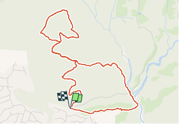

Length
6.6 km

Max alt
107 m

Uphill gradient
159 m
Km-Effort
8.8 km

Min alt
16 m

Downhill gradient
157 m
Boucle
Yes
Creation date :
2025-02-26 15:53:24.554
Updated on :
2025-02-26 15:53:47.666
1h59
Difficulty : Medium

FREE GPS app for hiking
 SityTrail
IGN / Geographical institutes
SityTrail Plus
The world is yours!
About
Trail Walking of 6.6 km to be discovered at Provence-Alpes-Côte d'Azur, Var, Saint-Raphaël. This trail is proposed by cb8310.
Positioning
Country:
France
Region :
Provence-Alpes-Côte d'Azur
Department/Province :
Var
Municipality :
Saint-Raphaël
Location:
Unknown
Start:(Dec)
Start:(UTM)
324357 ; 4813682 (32T) N.
Comments