


Tourtouse

loic09
User
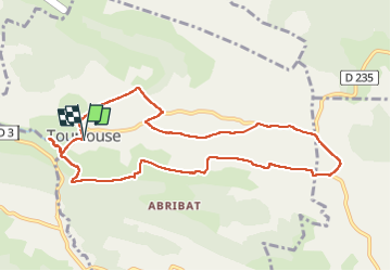

Length
10.4 km

Max alt
473 m

Uphill gradient
221 m
Km-Effort
13.3 km

Min alt
362 m

Downhill gradient
219 m
Boucle
Yes
Creation date :
2025-02-16 08:02:49.731
Updated on :
2025-02-27 12:58:06.221
2h48
Difficulty : Very easy

FREE GPS app for hiking
 SityTrail
IGN / Geographical institutes
SityTrail Plus
The world is yours!
About
Trail Walking of 10.4 km to be discovered at Occitania, Ariège, Tourtouse. This trail is proposed by loic09.
Description
Boucle de Nadot
Positioning
Country:
France
Region :
Occitania
Department/Province :
Ariège
Municipality :
Tourtouse
Location:
Unknown
Start:(Dec)
Start:(UTM)
347361 ; 4772811 (31T) N.
Comments