


Schoenembourg

LUTZMarc
User
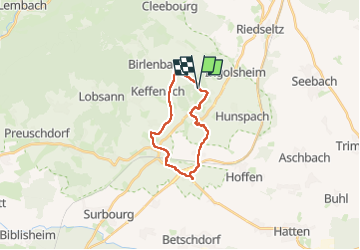

Length
16.4 km

Max alt
217 m

Uphill gradient
288 m
Km-Effort
20 km

Min alt
140 m

Downhill gradient
293 m
Boucle
Yes
Creation date :
2025-02-27 08:08:35.786
Updated on :
2025-02-27 14:05:29.194
4h06
Difficulty : Easy

FREE GPS app for hiking
 SityTrail
IGN / Geographical institutes
SityTrail Plus
The world is yours!
About
Trail Walking of 16.4 km to be discovered at Grand Est, Bas-Rhin, Hunspach. This trail is proposed by LUTZMarc.
Positioning
Country:
France
Region :
Grand Est
Department/Province :
Bas-Rhin
Municipality :
Hunspach
Location:
Unknown
Start:(Dec)
Start:(UTM)
420328 ; 5424257 (32U) N.
Comments