


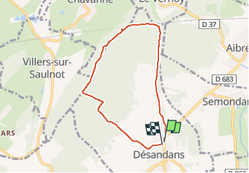
Desandans (groupe)

jacthiry
User

Length
6.7 km

Max alt
517 m

Uphill gradient
158 m
Km-Effort
8.8 km

Min alt
371 m

Downhill gradient
150 m
Boucle
Yes
Creation date :
2025-02-27 12:54:26.607
Updated on :
2025-02-27 15:16:03.872
2h21
Difficulty : Medium

FREE GPS app for hiking
 SityTrail
IGN / Geographical institutes
SityTrail Plus
The world is yours!
About
Trail Walking of 6.7 km to be discovered at Bourgogne-Franche-Comté, Doubs, Désandans. This trail is proposed by jacthiry.
Positioning
Country:
France
Region :
Bourgogne-Franche-Comté
Department/Province :
Doubs
Municipality :
Désandans
Location:
Unknown
Start:(Dec)
Start:(UTM)
325176 ; 5267319 (32T) N.
Comments