


Routo St Jeannet Puimoisson

taguette
User
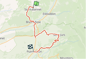

Length
32 km

Max alt
888 m

Uphill gradient
883 m
Km-Effort
43 km

Min alt
469 m

Downhill gradient
783 m
Boucle
No
Creation date :
2025-02-27 07:01:50.797
Updated on :
2025-02-27 15:33:32.483
8h30
Difficulty : Very difficult

FREE GPS app for hiking
 SityTrail
IGN / Geographical institutes
SityTrail Plus
The world is yours!
About
Trail Walking of 32 km to be discovered at Provence-Alpes-Côte d'Azur, Alpes-de-Haute-Provence, Saint-Jeannet. This trail is proposed by taguette.
Positioning
Country:
France
Region :
Provence-Alpes-Côte d'Azur
Department/Province :
Alpes-de-Haute-Provence
Municipality :
Saint-Jeannet
Location:
Unknown
Start:(Dec)
Start:(UTM)
269269 ; 4870699 (32T) N.
Comments