


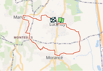
Lucenay

Thomasdanielle
User

Length
9.2 km

Max alt
396 m

Uphill gradient
222 m
Km-Effort
12.2 km

Min alt
177 m

Downhill gradient
221 m
Boucle
Yes
Creation date :
2025-02-27 13:06:12.0
Updated on :
2025-02-27 16:12:48.111

FREE GPS app for hiking
 SityTrail
IGN / Geographical institutes
SityTrail Plus
The world is yours!
About
Trail of 9.2 km to be discovered at Auvergne-Rhône-Alpes, Rhône, Lucenay. This trail is proposed by Thomasdanielle.
Description
Parking mairie
Positioning
Country:
France
Region :
Auvergne-Rhône-Alpes
Department/Province :
Rhône
Municipality :
Lucenay
Location:
Unknown
Start:(Dec)
Start:(UTM)
631968 ; 5085577 (31T) N.
Comments