


St Cyr le Chatoux - Crêt Lacrampe

Mariolebeno
User
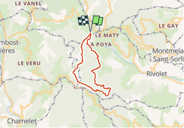

Length
10.3 km

Max alt
839 m

Uphill gradient
352 m
Km-Effort
15 km

Min alt
582 m

Downhill gradient
351 m
Boucle
Yes
Creation date :
2025-02-27 13:31:18.612
Updated on :
2025-02-28 06:59:30.174
3h24
Difficulty : Easy

FREE GPS app for hiking
 SityTrail
IGN / Geographical institutes
SityTrail Plus
The world is yours!
About
Trail Walking of 10.3 km to be discovered at Auvergne-Rhône-Alpes, Rhône, Saint-Cyr-le-Chatoux. This trail is proposed by Mariolebeno.
Positioning
Country:
France
Region :
Auvergne-Rhône-Alpes
Department/Province :
Rhône
Municipality :
Saint-Cyr-le-Chatoux
Location:
Unknown
Start:(Dec)
Start:(UTM)
620479 ; 5097985 (31T) N.
Comments