


Fontiès-Cabardès (Les Auges-Le Bernardou

Combaut11
User
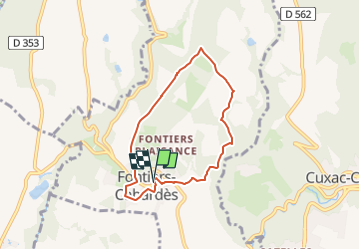

Length
6.4 km

Max alt
746 m

Uphill gradient
164 m
Km-Effort
8.5 km

Min alt
594 m

Downhill gradient
164 m
Boucle
Yes
Creation date :
2025-02-27 20:16:21.201
Updated on :
2025-02-27 20:19:12.611
1h56
Difficulty : Medium

FREE GPS app for hiking
 SityTrail
IGN / Geographical institutes
SityTrail Plus
The world is yours!
About
Trail Walking of 6.4 km to be discovered at Occitania, Aude, Fontiers-Cabardès. This trail is proposed by Combaut11.
Positioning
Country:
France
Region :
Occitania
Department/Province :
Aude
Municipality :
Fontiers-Cabardès
Location:
Unknown
Start:(Dec)
Start:(UTM)
439057 ; 4802184 (31T) N.
Comments