


Rando NJL - GR58 - JOUR 3

Domlouise
User

Length
37 km

Max alt
2648 m

Uphill gradient
2750 m
Km-Effort
75 km

Min alt
1188 m

Downhill gradient
2986 m
Boucle
No
Creation date :
2025-02-28 22:15:03.146
Updated on :
2025-02-28 22:15:31.728
17h00
Difficulty : Very difficult
1m
Difficulty : Very easy

FREE GPS app for hiking
 SityTrail
IGN / Geographical institutes
SityTrail Plus
The world is yours!
About
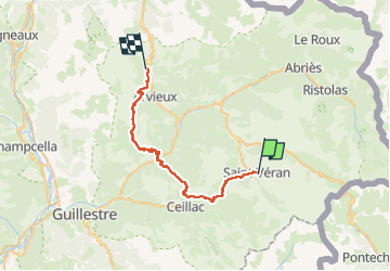
Trail Walking of 37 km to be discovered at Provence-Alpes-Côte d'Azur, Hautes-Alpes, Saint-Véran. This trail is proposed by Domlouise.
Positioning
Country:
France
Region :
Provence-Alpes-Côte d'Azur
Department/Province :
Hautes-Alpes
Municipality :
Saint-Véran
Location:
Unknown
Start:(Dec)
Start:(UTM)
331362 ; 4951660 (32T) N.
Comments