


depart bolandoz; le temps par les gouffres version 2

gerardmicheline
User
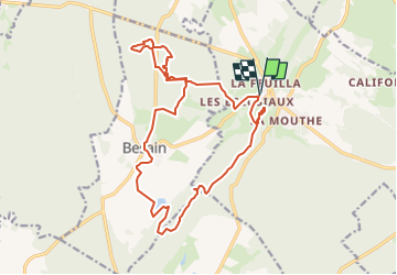

Length
19 km

Max alt
681 m

Uphill gradient
296 m
Km-Effort
23 km

Min alt
519 m

Downhill gradient
296 m
Boucle
Yes
Creation date :
2025-03-01 11:55:03.32
Updated on :
2025-03-01 13:04:13.902
5h13
Difficulty : Very difficult

FREE GPS app for hiking
 SityTrail
IGN / Geographical institutes
SityTrail Plus
The world is yours!
About
Trail Walking of 19 km to be discovered at Bourgogne-Franche-Comté, Jura, Montrond. This trail is proposed by gerardmicheline.
Positioning
Country:
France
Region :
Bourgogne-Franche-Comté
Department/Province :
Jura
Municipality :
Montrond
Location:
Unknown
Start:(Dec)
Start:(UTM)
716033 ; 5186505 (31T) N.
Comments