


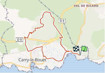
Le Vallon de Jaume par les Grottes

JMJ42
User

Length
10.1 km

Max alt
151 m

Uphill gradient
294 m
Km-Effort
14 km

Min alt
3 m

Downhill gradient
296 m
Boucle
Yes
Creation date :
2025-03-01 12:28:24.748
Updated on :
2025-03-01 12:29:54.749
3h11
Difficulty : Medium

FREE GPS app for hiking
 SityTrail
IGN / Geographical institutes
SityTrail Plus
The world is yours!
About
Trail Walking of 10.1 km to be discovered at Provence-Alpes-Côte d'Azur, Bouches-du-Rhône, Carry-le-Rouet. This trail is proposed by JMJ42.
Positioning
Country:
France
Region :
Provence-Alpes-Côte d'Azur
Department/Province :
Bouches-du-Rhône
Municipality :
Carry-le-Rouet
Location:
Unknown
Start:(Dec)
Start:(UTM)
676767 ; 4800166 (31T) N.
Comments