


Ah01035

pe78
User
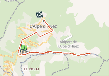

Length
10.1 km

Max alt
1847 m

Uphill gradient
614 m
Km-Effort
17.1 km

Min alt
1426 m

Downhill gradient
236 m
Boucle
No
Creation date :
2025-03-01 12:22:42.0
Updated on :
2025-03-01 16:04:10.519
3h40
Difficulty : Difficult

FREE GPS app for hiking
 SityTrail
IGN / Geographical institutes
SityTrail Plus
The world is yours!
About
Trail Walking of 10.1 km to be discovered at Auvergne-Rhône-Alpes, Isère, Huez. This trail is proposed by pe78.
Positioning
Country:
France
Region :
Auvergne-Rhône-Alpes
Department/Province :
Isère
Municipality :
Huez
Location:
Unknown
Start:(Dec)
Start:(UTM)
268354 ; 4996174 (32T) N.
Comments