


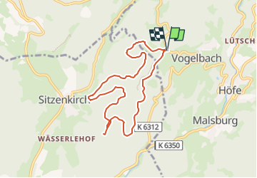
Parking Lindenbückle - Salneck - Sintzenkircherweg - Burghaldenweg - Schlossweg - Lange Ebene Hûtte - Vogelbacherweg et retour

patrickbeyrath
User

Length
7.6 km

Max alt
659 m

Uphill gradient
297 m
Km-Effort
11.6 km

Min alt
450 m

Downhill gradient
297 m
Boucle
Yes
Creation date :
2025-03-02 09:05:48.025
Updated on :
2025-03-02 09:29:38.464
2h38
Difficulty : Medium

FREE GPS app for hiking
 SityTrail
IGN / Geographical institutes
SityTrail Plus
The world is yours!
About
Trail Walking of 7.6 km to be discovered at Baden-Württemberg, Landkreis Lörrach, Malsburg-Marzell. This trail is proposed by patrickbeyrath.
Positioning
Country:
Germany
Region :
Baden-Württemberg
Department/Province :
Landkreis Lörrach
Municipality :
Malsburg-Marzell
Location:
Unknown
Start:(Dec)
Start:(UTM)
402308 ; 5288687 (32T) N.
Comments