


vttae moustache sam

peter06
User
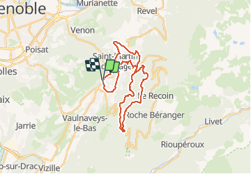

Length
32 km

Max alt
1232 m

Uphill gradient
1115 m
Km-Effort
47 km

Min alt
410 m

Downhill gradient
1116 m
Boucle
Yes
Creation date :
2015-06-23 00:00:00.0
Updated on :
2015-06-23 00:00:00.0
3h31
Difficulty : Unknown

FREE GPS app for hiking
 SityTrail
IGN / Geographical institutes
SityTrail Plus
The world is yours!
About
Trail Cycle of 32 km to be discovered at Auvergne-Rhône-Alpes, Isère, Vaulnaveys-le-Haut. This trail is proposed by peter06.
Positioning
Country:
France
Region :
Auvergne-Rhône-Alpes
Department/Province :
Isère
Municipality :
Vaulnaveys-le-Haut
Location:
Unknown
Start:(Dec)
Start:(UTM)
722142 ; 5001903 (31T) N.
Comments