


mi

hal2012
User
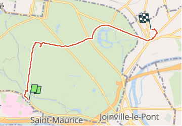

Length
5.6 km

Max alt
74 m

Uphill gradient
38 m
Km-Effort
6.1 km

Min alt
46 m

Downhill gradient
33 m
Boucle
No
Creation date :
2025-03-02 11:47:55.268
Updated on :
2025-03-02 14:41:21.642
1h17
Difficulty : Medium

FREE GPS app for hiking
 SityTrail
IGN / Geographical institutes
SityTrail Plus
The world is yours!
About
Trail Walking of 5.6 km to be discovered at Ile-de-France, Paris, Paris. This trail is proposed by hal2012.
Positioning
Country:
France
Region :
Ile-de-France
Department/Province :
Paris
Municipality :
Paris
Location:
12th Arrondissement
Start:(Dec)
Start:(UTM)
458369 ; 5407826 (31U) N.
Comments