


Fontcouverte

Licianus2
User GUIDE
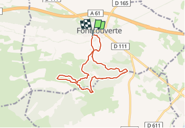

Length
7.4 km

Max alt
193 m

Uphill gradient
155 m
Km-Effort
9.5 km

Min alt
79 m

Downhill gradient
154 m
Boucle
Yes
Creation date :
2025-03-02 13:23:21.035
Updated on :
2025-03-11 19:29:02.586
2h09
Difficulty : Medium

FREE GPS app for hiking
 SityTrail
IGN / Geographical institutes
SityTrail Plus
The world is yours!
About
Trail Walking of 7.4 km to be discovered at Occitania, Aude, Fontcouverte. This trail is proposed by Licianus2.
Description
Variante au tracé balisé pour éviter le maximum de parties goudronnées. Les pistes et sentiers, encombrés par les arbres et arbustes abattus par le dernier incendie, sont à nouveau praticables et dégagés.
Photos


Positioning
Country:
France
Region :
Occitania
Department/Province :
Aude
Municipality :
Fontcouverte
Location:
Unknown
Start:(Dec)
Start:(UTM)
474541 ; 4779458 (31T) N.
Comments