Trail Mountain bike Saint-Amans-Valtoret - 2010-08-09 - 12h12m24 - Photo

2010-08-09 - 12h12m24

 macleon
macleon

User

© OpenStreetMap contributors
Length
Length
38 km
Max alt
Max alt
829 m
Uphill gradient
Uphill gradient
1001 m
Km-Effort
Km-Effort  
51 km
Min alt
Min alt
248 m
Downhill gradient
Downhill gradient
1001 m
Boucle
Boucle
Yes
Creation date :
2014-12-10 00:00:00.0
Updated on :
2014-12-10 00:00:00.0

(0 Reviews)

Mountain bike
Mountain bike
--
Difficulty : Unknown

Scan this QR Code to open this trail in the SityTrail application

FREE GPS app for hiking

Logo SityTrail SityTrail

IGN / Geographical institutes

Download SityTrail from the App Store Download SityTrail from Google Play

Logo SityTrail SityTrail World

The world is yours!

Download SityTrail from the App Store Download SityTrail from Google Play Download SityTrail on Huawei AppGallery

About

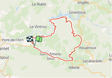
Trail Mountain bike of 38 km to be discovered at Occitania, Tarn, Saint-Amans-Valtoret. This trail is proposed by macleon.

Elevation profile

Photos

Points of interest

Point of interest Bout-du-Pont-de-Larn - Gite été 2011 - Photo
macleon
BOUT-DU-PONT-DE-LARN 

Positioning

Country:
France
Region :
Occitania
Department/Province :
Tarn
Municipality :
Saint-Amans-Valtoret
Location:
Unknown
Start:(UTM)
455789 ; 4815856 (31T) N.

Trails nearby

Trail Walking Le Vintrou - la Fontaine d'Artigues - Photo
Walking
Pierre11

Walking

Easy
Le Vintrou, Occitania, Tarn, France
13.5 km | 18.7 km-effort
4h 4min
Yes
Trail Walking Pont-de-Larn - Sagnecroze Vintrou Betges - Photo
Walking
miqueljp

Walking

Medium
(1)
Pont-de-Larn, Occitania, Tarn, France
10.3 km | 13.8 km-effort
2h 45min
Yes
Trail Walking Pont-de-Larn - saint baudille - Photo
Walking
ablatge

Walking

Medium
Pont-de-Larn, Occitania, Tarn, France
6.8 km | 8.7 km-effort
1h 50min
Yes
Trail Walking Saint-Amans-Soult - Le sentier des Gentilshommes Verriers - Saint Amand Soult - Photo
Walking
tracegps

Walking

Medium
Saint-Amans-Soult, Occitania, Tarn, France
19.9 km | 31 km-effort
5h 30min
Yes
Trail Walking Pont-de-Larn - Les gorges du Banquet - Pont de l'Arn - Photo
Walking
tracegps

Walking

Medium
Pont-de-Larn, Occitania, Tarn, France
18.2 km | 27 km-effort
6h 0min
Yes
Trail Walking Mazamet - Hautpoul - Photo
Walking
DENNEBECQ

Walking

Medium
Mazamet, Occitania, Tarn, France
13.5 km | 20 km-effort
4h 3min
No
Trail Walking Pont-de-Larn - les hauts de la môle variante - Photo
Walking
cappelle

Walking

Medium
Pont-de-Larn, Occitania, Tarn, France
12.1 km | 15.3 km-effort
3h 29min
Yes
Trail Walking Le Vintrou - gorges du banquet lac St peyres  - Photo
Walking

Walking

Medium
Le Vintrou, Occitania, Tarn, France
14.6 km | 22 km-effort
6h 51min
Yes
Trail Cycle Mazamet - Mazamet  Pic de Nore  Mazamet - Photo
Cycle
jpbearnais

Cycle

Medium
Mazamet, Occitania, Tarn, France
46 km | 61 km-effort
3h 4min
Yes


Close
My subscriptions