


Chatebier(moulin)

jacthiry
User
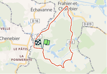

Length
7.5 km

Max alt
426 m

Uphill gradient
135 m
Km-Effort
9.3 km

Min alt
354 m

Downhill gradient
134 m
Boucle
Yes
Creation date :
2025-03-02 14:14:14.95
Updated on :
2025-03-02 16:15:00.801
1h59
Difficulty : Medium

FREE GPS app for hiking
 SityTrail
IGN / Geographical institutes
SityTrail Plus
The world is yours!
About
Trail Walking of 7.5 km to be discovered at Bourgogne-Franche-Comté, Haute-Saône, Frahier-et-Chatebier. This trail is proposed by jacthiry.
Positioning
Country:
France
Region :
Bourgogne-Franche-Comté
Department/Province :
Haute-Saône
Municipality :
Frahier-et-Chatebier
Location:
Unknown
Start:(Dec)
Start:(UTM)
329831 ; 5278974 (32T) N.
Comments