


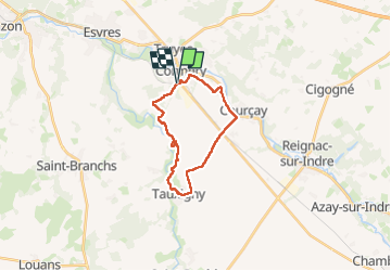
Cormery gare - Tauxigny - 19.5km 170m 4h35 (40mn) - 2025 03 02

Orcal37
User GUIDE

Length
18.8 km

Max alt
100 m

Uphill gradient
166 m
Km-Effort
21 km

Min alt
68 m

Downhill gradient
167 m
Boucle
Yes
Creation date :
2025-03-02 09:50:04.754
Updated on :
2025-03-08 12:47:04.807
4h35
Difficulty : Easy

FREE GPS app for hiking
 SityTrail
IGN / Geographical institutes
SityTrail Plus
The world is yours!
About
Trail Walking of 18.8 km to be discovered at Centre-Loire Valley, Indre-et-Loire, Cormery. This trail is proposed by Orcal37.
Description
Cormery gare - Tauxigny - 19.5km 170m 4h35 (40mn) - 2025 03 02
Photos
 - 2025 03 02 - Photo 1")
 - 2025 03 02 - Photo 2")
 - 2025 03 02 - Photo 3")
 - 2025 03 02 - Photo 4")
 - 2025 03 02 - Photo 5")
 - 2025 03 02 - Photo 6")
 - 2025 03 02 - Photo 7")
 - 2025 03 02 - Photo 8")
 - 2025 03 02 - Photo 9")
Positioning
Country:
France
Region :
Centre-Loire Valley
Department/Province :
Indre-et-Loire
Municipality :
Cormery
Location:
Unknown
Start:(Dec)
Start:(UTM)
336146 ; 5236641 (31T) N.
Comments