


Mortemer

JMCMoreau
User
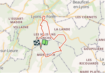

Length
11.2 km

Max alt
194 m

Uphill gradient
223 m
Km-Effort
14.3 km

Min alt
89 m

Downhill gradient
234 m
Boucle
Yes
Creation date :
2025-03-02 18:09:57.036
Updated on :
2025-03-02 18:11:36.258
3h30
Difficulty : Medium

FREE GPS app for hiking
 SityTrail
IGN / Geographical institutes
SityTrail Plus
The world is yours!
About
Trail Walking of 11.2 km to be discovered at Normandy, Eure, Lisors. This trail is proposed by JMCMoreau.
Positioning
Country:
France
Region :
Normandy
Department/Province :
Eure
Municipality :
Lisors
Location:
Unknown
Start:(Dec)
Start:(UTM)
389235 ; 5470151 (31U) N.
Comments