


vertrieu 1

robert gallet
User
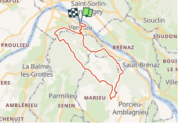

Length
14.8 km

Max alt
421 m

Uphill gradient
523 m
Km-Effort
22 km

Min alt
196 m

Downhill gradient
518 m
Boucle
Yes
Creation date :
2025-03-03 10:20:05.634
Updated on :
2025-03-03 10:20:48.307
4h57
Difficulty : Very difficult

FREE GPS app for hiking
 SityTrail
IGN / Geographical institutes
SityTrail Plus
The world is yours!
About
Trail Walking of 14.8 km to be discovered at Auvergne-Rhône-Alpes, Isère, Vertrieu. This trail is proposed by robert gallet.
Positioning
Country:
France
Region :
Auvergne-Rhône-Alpes
Department/Province :
Isère
Municipality :
Vertrieu
Location:
Unknown
Start:(Dec)
Start:(UTM)
683720 ; 5082862 (31T) N.
Comments