


reco Roquebrune 2

ARPF3
User
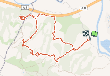


4h17
Difficulty : Difficult

FREE GPS app for hiking
 SityTrail
IGN / Geographical institutes
SityTrail Plus
The world is yours!
About
Trail Walking of 8.3 km to be discovered at Provence-Alpes-Côte d'Azur, Var, Roquebrune-sur-Argens. This trail is proposed by ARPF3.
Description
Nombreux passages aériens et équipés jusqu'en haut des 3 Croix (passage en aller retour sur ce rocher), passage aérien et en partie non équipé ensuite, descente vers le Saint Trou que nous n'avons pas vraiment trouvé, et remontée pour retour au parking.
Positioning
Comments