


2021-10-18_09h21m16_exp_La Tour-d'Aigues Rando vttae

Alain Derrives
User
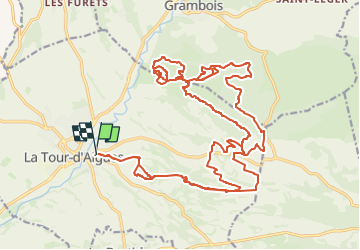

Length
34 km

Max alt
571 m

Uphill gradient
925 m
Km-Effort
46 km

Min alt
260 m

Downhill gradient
924 m
Boucle
Yes
Creation date :
2025-03-03 14:55:25.192
Updated on :
2025-03-03 15:05:18.676
3h12
Difficulty : Very difficult

FREE GPS app for hiking
 SityTrail
IGN / Geographical institutes
SityTrail Plus
The world is yours!
About
Trail Mountain bike of 34 km to be discovered at Provence-Alpes-Côte d'Azur, Vaucluse, La Tour-d'Aigues. This trail is proposed by Alain Derrives.
Positioning
Country:
France
Region :
Provence-Alpes-Côte d'Azur
Department/Province :
Vaucluse
Municipality :
La Tour-d'Aigues
Location:
Unknown
Start:(Dec)
Start:(UTM)
705818 ; 4844531 (31T) N.
Comments