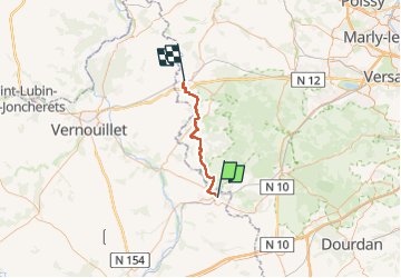
Trail Walking Épernon - Epernon - Houdan - Photo
 chessyca
chessyca

User GUIDE

© OpenStreetMap contributors
Length
Length
34 km
Max alt
Max alt
191 m
Uphill gradient
Uphill gradient
402 m
Km-Effort
Km-Effort  
40 km
Min alt
Min alt
94 m
Downhill gradient
Downhill gradient
422 m
Boucle
Boucle
No
Creation date :
2025-03-03 07:23:56.253
Updated on :
2025-03-03 20:04:16.06

(0 Reviews)

Walking
Walking
6h57
Difficulty : Very difficult

Scan this QR Code to open this trail in the SityTrail application

FREE GPS app for hiking

Logo SityTrail SityTrail

IGN / Geographical institutes

Download SityTrail from the App Store Download SityTrail from Google Play

Logo SityTrail SityTrail Plus

The world is yours!

Download SityTrail from the App Store Download SityTrail from Google Play Download SityTrail on Huawei AppGallery

About

Trail Walking of 34 km to be discovered at Centre-Loire Valley, Eure-et-Loir, Épernon. This trail is proposed by chessyca.

Description

1 ere étape de la traversée des Yvelines par le grp avec quelques petites diverticules.
Pas de difficultés hormis la distance
Menée par moi même pour le rando club yerrois

Elevation profile

Photos

21 photos in total. Please click on a photo to see them all in the gallery.

Positioning

Country:
France
Region :
Centre-Loire Valley
Department/Province :
Eure-et-Loir
Municipality :
Épernon
Location:
Unknown
Start:(UTM)
402830 ; 5384406 (31U) N.


Close
My subscriptions