


Pic ouest de Côté Belle

orsel
User GUIDE
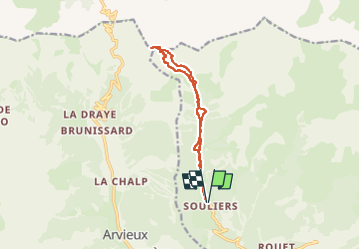

Length
11.8 km

Max alt
2832 m

Uphill gradient
1002 m
Km-Effort
25 km

Min alt
1828 m

Downhill gradient
1000 m
Boucle
Yes
Creation date :
2025-03-03 07:10:44.356
Updated on :
2025-03-03 17:15:04.562
5h50
Difficulty : Medium

FREE GPS app for hiking
 SityTrail
IGN / Geographical institutes
SityTrail Plus
The world is yours!
About
Trail Touring skiing of 11.8 km to be discovered at Provence-Alpes-Côte d'Azur, Hautes-Alpes, Château-Ville-Vieille. This trail is proposed by orsel.
Positioning
Country:
France
Region :
Provence-Alpes-Côte d'Azur
Department/Province :
Hautes-Alpes
Municipality :
Château-Ville-Vieille
Location:
Unknown
Start:(Dec)
Start:(UTM)
323387 ; 4960494 (32T) N.
Comments