


Puy L'Evêque via Luzech 2025

Gpoujade
User
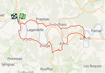

Length
42 km

Max alt
278 m

Uphill gradient
846 m
Km-Effort
53 km

Min alt
78 m

Downhill gradient
847 m
Boucle
Yes
Creation date :
2025-03-04 10:33:50.932
Updated on :
2025-03-05 11:35:13.003
3h40
Difficulty : Very difficult

FREE GPS app for hiking
 SityTrail
IGN / Geographical institutes
SityTrail Plus
The world is yours!
About
Trail Mountain bike of 42 km to be discovered at Occitania, Lot, Puy-l'Évêque. This trail is proposed by Gpoujade.
Description
Boucle
Positioning
Country:
France
Region :
Occitania
Department/Province :
Lot
Municipality :
Puy-l'Évêque
Location:
Unknown
Start:(Dec)
Start:(UTM)
351349 ; 4929465 (31T) N.
Comments