


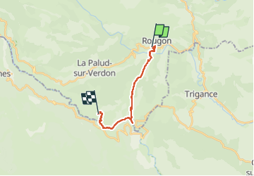
Verdon sentier Blanc Martel

taguette
User

Length
16.4 km

Max alt
939 m

Uphill gradient
1402 m
Km-Effort
35 km

Min alt
562 m

Downhill gradient
1291 m
Boucle
No
Creation date :
2025-03-04 07:46:34.657
Updated on :
2025-03-04 13:45:45.305
5h58
Difficulty : Very difficult

FREE GPS app for hiking
 SityTrail
IGN / Geographical institutes
SityTrail Plus
The world is yours!
About
Trail Walking of 16.4 km to be discovered at Provence-Alpes-Côte d'Azur, Alpes-de-Haute-Provence, Rougon. This trail is proposed by taguette.
Positioning
Country:
France
Region :
Provence-Alpes-Côte d'Azur
Department/Province :
Alpes-de-Haute-Provence
Municipality :
Rougon
Location:
Unknown
Start:(Dec)
Start:(UTM)
290614 ; 4852303 (32T) N.
Comments