


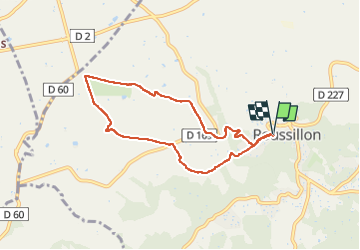
Roussillon - les Buis

ash
User

Length
7.4 km

Max alt
305 m

Uphill gradient
144 m
Km-Effort
9.3 km

Min alt
181 m

Downhill gradient
143 m
Boucle
Yes
Creation date :
2025-03-04 14:20:05.0
Updated on :
2025-03-04 16:02:43.256

FREE GPS app for hiking
 SityTrail
IGN / Geographical institutes
SityTrail Plus
The world is yours!
About
Trail of 7.4 km to be discovered at Provence-Alpes-Côte d'Azur, Vaucluse, Roussillon. This trail is proposed by ash.
Description
Aller par GR6 : super / retour par GR pays : beaucoup route = bof
Photos


Positioning
Country:
France
Region :
Provence-Alpes-Côte d'Azur
Department/Province :
Vaucluse
Municipality :
Roussillon
Location:
Unknown
Start:(Dec)
Start:(UTM)
683881 ; 4863588 (31T) N.
Comments