


VINCENNES

jm-barlier@sfr.fr
User
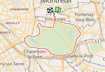

Length
15 km

Max alt
69 m

Uphill gradient
104 m
Km-Effort
16.4 km

Min alt
45 m

Downhill gradient
106 m
Boucle
Yes
Creation date :
2025-03-05 09:01:01.387
Updated on :
2025-03-05 10:50:10.803
1h48
Difficulty : Difficult

FREE GPS app for hiking
 SityTrail
IGN / Geographical institutes
SityTrail Plus
The world is yours!
About
Trail Walking of 15 km to be discovered at Ile-de-France, Val-de-Marne, Vincennes. This trail is proposed by jm-barlier@sfr.fr .
Positioning
Country:
France
Region :
Ile-de-France
Department/Province :
Val-de-Marne
Municipality :
Vincennes
Location:
Unknown
Start:(Dec)
Start:(UTM)
458824 ; 5410881 (31U) N.
Comments