


Château d'Entrecasteaux 05-03-2025

Christiancordin
User

Length
15.5 km

Max alt
317 m

Uphill gradient
528 m
Km-Effort
23 km

Min alt
148 m

Downhill gradient
527 m
Boucle
Yes
Creation date :
2025-03-05 08:31:40.422
Updated on :
2025-03-06 17:48:31.399
4h21
Difficulty : Medium

FREE GPS app for hiking
 SityTrail
IGN / Geographical institutes
SityTrail Plus
The world is yours!
About
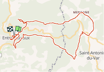
Trail Walking of 15.5 km to be discovered at Provence-Alpes-Côte d'Azur, Var, Entrecasteaux. This trail is proposed by Christiancordin.
Description
Entrecasteaux, chapelle Ste Anne, le Défens de Valpeironne, château Mentone, les bastides d'Estelle, pont Ste Catherine, la Bresque, le lavoir.
Photos


Positioning
Country:
France
Region :
Provence-Alpes-Côte d'Azur
Department/Province :
Var
Municipality :
Entrecasteaux
Location:
Unknown
Start:(Dec)
Start:(UTM)
277106 ; 4821750 (32T) N.
Comments