Trail Running Cheptainville - 32KDUO - 16/03/2025-10905638 - Photo

32KDUO - 16/03/2025-10905638

© OpenStreetMap contributors
Length
Length
56 km
Max alt
Max alt
164 m
Uphill gradient
Uphill gradient
1232 m
Km-Effort
Km-Effort  
72 km
Min alt
Min alt
62 m
Downhill gradient
Downhill gradient
1232 m
Boucle
Boucle
Yes
Creation date :
2025-03-05 17:18:54.081
Updated on :
2025-03-10 14:17:12.064

(0 Reviews)

Running
Running
0m
Difficulty : Difficult

Scan this QR Code to open this trail in the SityTrail application

FREE GPS app for hiking

Logo SityTrail SityTrail

IGN / Geographical institutes

Download SityTrail from the App Store Download SityTrail from Google Play

Logo SityTrail SityTrail Plus

The world is yours!

Download SityTrail from the App Store Download SityTrail from Google Play Download SityTrail on Huawei AppGallery

About

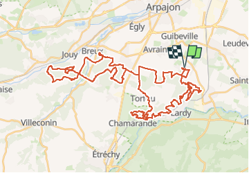
Trail Running of 56 km to be discovered at Ile-de-France, Essonne, Cheptainville. This trail is proposed by Clément Baldzuhn.

Description

Fusion du trail du Cheptain trail et du trail du Taco ! Tiens, toi ! Viens t'en courir avec moi par les sentiers, dans les bois, la boue et sous la pluie ! La licorne qui est en toi frétille d'impatience de vire cet indomptable moment !

Elevation profile

Positioning

Country:
France
Region :
Ile-de-France
Department/Province :
Essonne
Municipality :
Cheptainville
Location:
Unknown
Start:(Dec)
Start:(UTM)
446066 ; 5377750 (31U) N.


Close
My subscriptions