


2025-03-05_18h47m15_SityTrail - 4373144 - devesset-st-jeures

Howen
User
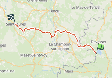

Length
23 km

Max alt
1145 m

Uphill gradient
557 m
Km-Effort
30 km

Min alt
894 m

Downhill gradient
603 m
Boucle
No
Creation date :
2025-03-05 17:47:15.253
Updated on :
2025-03-05 17:47:19.51

FREE GPS app for hiking
 SityTrail
IGN / Geographical institutes
SityTrail Plus
The world is yours!
About
Trail of 23 km to be discovered at Auvergne-Rhône-Alpes, Ardèche, Devesset. This trail is proposed by Howen.
Description
A tester...
Positioning
Country:
France
Region :
Auvergne-Rhône-Alpes
Department/Province :
Ardèche
Municipality :
Devesset
Location:
Unknown
Start:(Dec)
Start:(UTM)
608964 ; 4989368 (31T) N.
Comments