


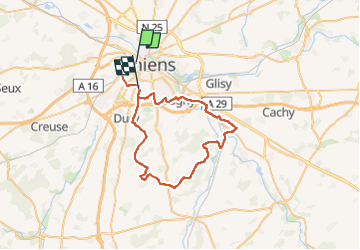
La boucle de Cottenchy

ORTAX
User

Length
47 km

Max alt
119 m

Uphill gradient
533 m
Km-Effort
54 km

Min alt
24 m

Downhill gradient
493 m
Boucle
No
Creation date :
2025-03-05 18:18:14.0
Updated on :
2025-03-05 18:18:16.478

FREE GPS app for hiking
 SityTrail
IGN / Geographical institutes
SityTrail Plus
The world is yours!
About
Trail of 47 km to be discovered at Hauts-de-France, Somme, Amiens. This trail is proposed by ORTAX.
Positioning
Country:
France
Region :
Hauts-de-France
Department/Province :
Somme
Municipality :
Amiens
Location:
Unknown
Start:(Dec)
Start:(UTM)
448526 ; 5527352 (31U) N.
Comments