


123

Martînati
User
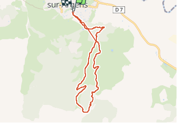

Length
8.8 km

Max alt
198 m

Uphill gradient
291 m
Km-Effort
12.7 km

Min alt
28 m

Downhill gradient
289 m
Boucle
Yes
Creation date :
2025-03-06 07:49:33.317
Updated on :
2025-03-06 11:13:21.313
3h23
Difficulty : Difficult

FREE GPS app for hiking
 SityTrail
IGN / Geographical institutes
SityTrail Plus
The world is yours!
About
Trail Walking of 8.8 km to be discovered at Provence-Alpes-Côte d'Azur, Var, Roquebrune-sur-Argens. This trail is proposed by Martînati.
Positioning
Country:
France
Region :
Provence-Alpes-Côte d'Azur
Department/Province :
Var
Municipality :
Roquebrune-sur-Argens
Location:
Unknown
Start:(Dec)
Start:(UTM)
308918 ; 4812443 (32T) N.
Comments