


Rougon Castellane

taguette
User
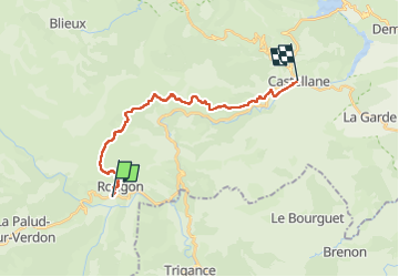

Length
19.2 km

Max alt
1249 m

Uphill gradient
640 m
Km-Effort
28 km

Min alt
713 m

Downhill gradient
699 m
Boucle
No
Creation date :
2025-03-06 06:57:25.98
Updated on :
2025-03-06 12:22:42.454
5h20
Difficulty : Very difficult

FREE GPS app for hiking
 SityTrail
IGN / Geographical institutes
SityTrail Plus
The world is yours!
About
Trail Walking of 19.2 km to be discovered at Provence-Alpes-Côte d'Azur, Alpes-de-Haute-Provence, Rougon. This trail is proposed by taguette.
Positioning
Country:
France
Region :
Provence-Alpes-Côte d'Azur
Department/Province :
Alpes-de-Haute-Provence
Municipality :
Rougon
Location:
Unknown
Start:(Dec)
Start:(UTM)
290624 ; 4852298 (32T) N.
Comments