


6 03 2025

alexoy
User

Length
10.2 km

Max alt
678 m

Uphill gradient
306 m
Km-Effort
14.3 km

Min alt
414 m

Downhill gradient
306 m
Boucle
Yes
Creation date :
2025-03-06 09:17:27.955
Updated on :
2025-03-06 13:27:57.831
4h10
Difficulty : Difficult

FREE GPS app for hiking
 SityTrail
IGN / Geographical institutes
SityTrail Plus
The world is yours!
About
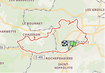
Trail Walking of 10.2 km to be discovered at Auvergne-Rhône-Alpes, Puy-de-Dôme, Châtel-Guyon. This trail is proposed by alexoy.
Photos


Positioning
Country:
France
Region :
Auvergne-Rhône-Alpes
Department/Province :
Puy-de-Dôme
Municipality :
Châtel-Guyon
Location:
Unknown
Start:(Dec)
Start:(UTM)
504443 ; 5084834 (31T) N.
Comments