Trail Walking Valdeblore - Mont Viroulet - Photo
 bozo1970
bozo1970

User

© OpenStreetMap contributors
Length
Length
15.1 km
Max alt
Max alt
1859 m
Uphill gradient
Uphill gradient
867 m
Km-Effort
Km-Effort  
27 km
Min alt
Min alt
1017 m
Downhill gradient
Downhill gradient
866 m
Boucle
Boucle
Yes
Creation date :
2025-03-06 09:11:16.0
Updated on :
2025-03-06 17:12:27.071

(0 Reviews)

Walking
Walking
4h19
Difficulty : Medium

Scan this QR Code to open this trail in the SityTrail application

FREE GPS app for hiking

Logo SityTrail SityTrail

IGN / Geographical institutes

Download SityTrail from the App Store Download SityTrail from Google Play

Logo SityTrail SityTrail Plus

The world is yours!

Download SityTrail from the App Store Download SityTrail from Google Play Download SityTrail on Huawei AppGallery

About

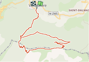
Trail Walking of 15.1 km to be discovered at Provence-Alpes-Côte d'Azur, Maritime Alps, Valdeblore. This trail is proposed by bozo1970.

Description

Départ de la Bolline
Église St Jacques balise 139
GR 52A
Vallon de la Couletta
Col de la Sėréna balise 127 en 45’ D 307 et 2km420
Très lisse et souple en sous bois
Parfait pour l’été
Vers plan d’Arous
Mont Viroulet
Sommet en 2h10’ D 869 et 6km
A/R en 4h15’ D 921 et 15km
Très agréable mais peu de vue
Véga a ado

Elevation profile

Photos

Positioning

Country:
France
Region :
Provence-Alpes-Côte d'Azur
Department/Province :
Maritime Alps
Municipality :
Valdeblore
Location:
Unknown
Start:(UTM)
353568 ; 4881164 (32T) N.


Close
My subscriptions