


Baous la Gaude et St Jeannet

puchol
User
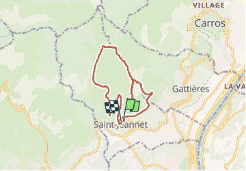

Length
14.8 km

Max alt
846 m

Uphill gradient
709 m
Km-Effort
24 km

Min alt
402 m

Downhill gradient
686 m
Boucle
Yes
Creation date :
2025-03-06 08:09:28.228
Updated on :
2025-03-06 15:38:44.825
7h27
Difficulty : Medium

FREE GPS app for hiking
 SityTrail
IGN / Geographical institutes
SityTrail Plus
The world is yours!
About
Trail Walking of 14.8 km to be discovered at Provence-Alpes-Côte d'Azur, Maritime Alps, Saint-Jeannet. This trail is proposed by puchol.
Positioning
Country:
France
Region :
Provence-Alpes-Côte d'Azur
Department/Province :
Maritime Alps
Municipality :
Saint-Jeannet
Location:
Unknown
Start:(Dec)
Start:(UTM)
350606 ; 4845685 (32T) N.
Comments